本节内容是整个初中地理的基础和重难点,课程内容围绕“人类认识地球形状的过 程”“用数据描述地球的大小”“了解经纬网及其运用”等知识点展开,重点落在“熟悉 经线与纬线、经度与纬度的划分和特征,以及经纬网定位”上。 通过本节的学习,可以对学生进行科学史教育,培养勇于探索科学的精神;有利于帮 助学生建立空间概念;为后面学习地球的运动及地图等知识做好铺垫。 ...[详情]
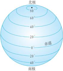
《地球和地球仪》(第1 课时) 教学目标 (一)知识与技能 1.知道地球的真实形状、大小,了解人类对地球形状的认识过程。 2 .知道地球仪是地球的模型,知道地轴、两极、本初子午线和赤道,了解地球仪的基 本要素。 3 .知道纬线的特征和纬度的变化规律,以及高、中、低纬和南、北半球的划分。 (二)过程与方法 1.通过了解人类探索地球形状的艰难过程,培养学生的观察能力和探索精神。 2.通过课堂制作简易地球仪的活动,培养学生的动手实践能力。 3.通过观察地球仪,列表概括纬线的基本特征,培养学生比较、分析问题的能力。 [详情]
关于人类对地球形状认识过程的探究活动 【活动内容】 学生用表演的形式模拟人类对地球形状的认识过程。 【活动目的】 让学生了解人类认识地球形状的过程(从猜想到实践;从不科学到科学), 从中受到科学观的教育。 [详情]
关于经纬网定点的探究活动 【活动内容】 室外活动竞赛课――利用经纬网确定任意地点的位置 【活动目的】 利用经纬网确定某地的地理位置 [详情]
 登录
登录